Introduction
Maritime zones are areas of the ocean that are subject to the jurisdiction of a particular coastal state. These zones are established in accordance with the United Nations Convention on the Law of the Sea (UNCLOS), which divides the ocean into several different zones, each with its own set of rules and regulations. The APHG (Advanced Placement Human Geography) curriculum includes a unit on maritime zones, which provides students with a comprehensive understanding of these important areas.

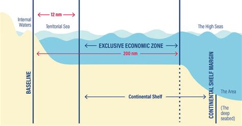
Territorial Waters
The territorial waters of a coastal state extend from the baseline (the low-water mark) to a distance of 12 nautical miles (22.2 km). Within this zone, the coastal state has full sovereignty and can exercise complete control over all activities, including fishing, mining, and navigation.
Contiguous Zone
The contiguous zone extends from the outer limit of the territorial waters to a distance of 24 nautical miles (44.4 km). In this zone, the coastal state has the right to enforce its customs, fiscal, immigration, and sanitary laws.
Exclusive Economic Zone
The exclusive economic zone (EEZ) extends from the outer limit of the contiguous zone to a distance of 200 nautical miles (370.4 km). In this zone, the coastal state has the exclusive right to exploit all natural resources, including fish, minerals, and oil. The coastal state also has jurisdiction over all activities related to economic exploitation, such as fishing, mining, and scientific research.
Continental Shelf
The continental shelf is the submerged extension of the continent. It extends from the outer limit of the EEZ to the edge of the continental margin. The coastal state has the exclusive right to explore and exploit the natural resources of the continental shelf, including oil, gas, and minerals.
High Seas
The high seas are the areas of the ocean that are not subject to the jurisdiction of any coastal state. These areas are open to all nations for navigation, fishing, and other activities. However, no nation can claim sovereignty over the high seas.
Key Statistics
- The total area of the world’s oceans is approximately 361 million square kilometers.
- The total area of the world’s EEZs is approximately 240 million square kilometers.
- The total area of the world’s continental shelves is approximately 35 million square kilometers.
- The total area of the world’s high seas is approximately 82 million square kilometers.
Creative Applications: Maritech
The study of maritime zones has led to the development of new technologies and applications, such as Maritech. Maritech is a term that refers to the use of technology to improve the management and use of marine resources. Maritech applications include:
- Ocean mapping: Using sonar and other technologies to create detailed maps of the ocean floor.
- Fishery management: Using satellite data and other technologies to track fish populations and manage fishing activities.
- Oil and gas exploration: Using seismic surveys and other technologies to locate oil and gas reserves.
Tables
Table 1: Maritime Zones
| Zone | Distance from Baseline | Jurisdiction |
|---|---|---|
| Territorial Waters | 12 nautical miles | Coastal State has full sovereignty |
| Contiguous Zone | 24 nautical miles | Coastal State can enforce customs, fiscal, immigration, and sanitary laws |
| Exclusive Economic Zone | 200 nautical miles | Coastal State has exclusive right to exploit natural resources and jurisdiction over economic activities |
| Continental Shelf | To the edge of the continental margin | Coastal State has exclusive right to explore and exploit natural resources |
| High Seas | Not subject to the jurisdiction of any coastal state | Open to all nations for navigation, fishing, and other activities |
Table 2: Key Statistics
| Statistic | Value |
|---|---|
| Total area of the world’s oceans | 361 million square kilometers |
| Total area of the world’s EEZs | 240 million square kilometers |
| Total area of the world’s continental shelves | 35 million square kilometers |
| Total area of the world’s high seas | 82 million square kilometers |
Table 3: Maritech Applications
| Application | Description |
|---|---|
| Ocean mapping | Using sonar and other technologies to create detailed maps of the ocean floor |
| Fishery management | Using satellite data and other technologies to track fish populations and manage fishing activities |
| Oil and gas exploration | Using seismic surveys and other technologies to locate oil and gas reserves |
Table 4: Pros and Cons of Maritime Zones
| Pros | Cons |
|---|---|
| Provide coastal states with exclusive rights to exploit natural resources | Can lead to disputes between coastal states |
| Help to protect marine ecosystems | Can restrict access to the high seas for other nations |
| Promote economic development | Can lead to overexploitation of marine resources |
Step-by-Step Approach to Establishing Maritime Zones
- Determine the baseline.
- Measure the distance from the baseline to establish the territorial waters.
- Measure the distance from the outer limit of the territorial waters to establish the contiguous zone.
- Measure the distance from the outer limit of the contiguous zone to establish the EEZ.
- Determine the extent of the continental shelf.
- Identify the areas of the high seas.
Frequently Asked Questions
-
What is the difference between territorial waters and the EEZ?
– Territorial waters are the areas of the ocean that are subject to the full sovereignty of the coastal state, while the EEZ is the area of the ocean where the coastal state has the exclusive right to exploit natural resources. -
What is the purpose of the contiguous zone?
– The contiguous zone is the area of the ocean where the coastal state can enforce its customs, fiscal, immigration, and sanitary laws. -
What is the significance of the continental shelf?
– The continental shelf is the area of the ocean where the coastal state has the exclusive right to explore and exploit natural resources. -
What is the status of the high seas?
– The high seas are the areas of the ocean that are not subject to the jurisdiction of any coastal state. -
How can maritime zones be used to promote economic development?
– Maritime zones can be used to promote economic development by providing coastal states with exclusive rights to exploit natural resources, such as fish, minerals, and oil. -
How can maritime zones be used to protect marine ecosystems?
– Maritime zones can be used to protect marine ecosystems by restricting activities that could damage the environment, such as pollution and overfishing. -
What are some of the challenges associated with managing maritime zones?
– Some of the challenges associated with managing maritime zones include disputes between coastal states, illegal fishing, and pollution. -
What is the future of maritime zones?
– The future of maritime zones is uncertain, but it is likely that they will continue to play an important role in the management and use of marine resources.
Conclusion
Maritime zones are important areas of the ocean that are subject to the jurisdiction of coastal states. These zones provide coastal states with exclusive rights to exploit natural resources and jurisdiction over economic activities. Maritime zones can also be used to protect marine ecosystems and promote economic development. However, there are also a number of challenges associated with managing maritime zones, including disputes between coastal states, illegal fishing, and pollution.