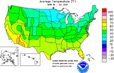
A reference map is a cartographic representation of the Earth’s surface or a portion of it, which provides a framework for understanding the distribution of features and phenomena. Reference maps typically display political boundaries, physical features (such as mountains, rivers, and lakes), and major cities and towns. They are a fundamental tool in geography, as they allow users to visualize and analyze the spatial relationships between different locations and features.

Characteristics of Reference Maps
Reference maps are characterized by their:
- Accuracy: A high level of accuracy is essential for reference maps, as they are used for precise location-based analysis.
- Scale: Reference maps can be created at various scales, from large-scale maps that show detailed features of a small area to small-scale maps that provide a broader overview of a larger region.
- Projection: Reference maps use different projections to represent the curved Earth’s surface on a flat plane. Common projections include the Mercator projection, which maintains correct shapes but distorts distances, and the Robinson projection, which balances accuracy and distortion.
- Symbols and Legends: Reference maps use a standardized set of symbols and colors to represent different features. Legends provide explanations of these symbols.
Types of Reference Maps
There are various types of reference maps, each designed to highlight specific aspects of the Earth’s surface:
- Political Maps: Depict political boundaries, such as countries, states, and counties.
- Physical Maps: Show natural features, such as mountains, rivers, and vegetation.
- Topographic Maps: Use contours to represent elevation.
- Thematic Maps: Focus on a particular theme, such as population density or climate zones.
- Atlases: Collections of reference maps bound together in a single volume.
Applications of Reference Maps
Reference maps have a wide range of applications in various fields, including:
- Geography: Understanding the distribution of physical and human features.
- History: Reconstructing past events based on historical maps.
- Planning and Development: Making informed decisions about land use and infrastructure.
- Navigation: Determining the location and route for travel.
- Education: Teaching students about geography and spatial relationships.
Common Mistakes to Avoid
When using reference maps, it is important to avoid common mistakes:
- Misinterpreting Scale: Failing to understand the scale of a map can lead to incorrect assumptions about the size and distance of features.
- Ignoring Projection: Not considering the projection used can distort the appearance of features and distances.
- Overreliance on Detail: Excessively focusing on specific details can obscure the overall pattern or distribution of features.
- Failure to Use Legends: Neglecting to consult the legend can lead to incorrect interpretation of symbols and features.
Strategies for Effective Reference Map Use
1. Determine the Purpose: Clearly define the purpose of the map and identify the specific features or information being sought.
2. Choose the Appropriate Map Type: Select a map type that aligns with the intended purpose.
3. Understand Scale and Projection: Examine the map’s scale and projection to interpret distances and relationships accurately.
4. Analyze the Legend: Familiarize yourself with the symbols and colors used to represent features.
5. Draw Comparisons: Compare different maps or layers to identify patterns and changes over time or across regions.
Tips and Tricks
1. Use a Magnifying Glass: Enlarging specific areas enhances detail visibility.
2. Trace the Map: Tracing features onto transparent paper allows for comparisons and overlays.
3. Combine Reference Maps: Layer multiple reference maps to create a comprehensive understanding.
4. Create a Digital Map: Use mapping software to create interactive and customizable maps.
Innovative Applications
1. Digital Reference Maps: Advances in technology have led to the development of digital reference maps that can be accessed and manipulated online. These maps incorporate data from various sources and allow users to zoom in, pan, and overlay different layers.
2. Interactive Maps: Interactive maps allow users to engage with the map and explore data visually. They can be used for education, planning, and decision-making purposes.
3. 3D Reference Maps: Emerging technologies such as virtual reality and augmented reality enable the creation of immersive 3D reference maps. These maps provide a more realistic representation of the Earth’s surface and facilitate spatial understanding.
Conclusion
Reference maps are a valuable tool in geography and various other fields. By understanding the definition, characteristics, types, and applications of reference maps, users can effectively navigate, analyze, and interpret spatial information. Common mistakes should be avoided, and effective strategies should be employed to ensure accurate and meaningful map use. Innovative applications of reference maps, such as digital and interactive maps, continue to expand the possibilities of spatial analysis and education.
| Type of Reference Map | Purpose | Example |
|---|---|---|
| Political Map | Depict political boundaries | World Map |
| Physical Map | Show natural features | USGS Topographic Map |
| Topographic Map | Represent elevation | Digital Elevation Model (DEM) |
| Thematic Map | Focus on a particular theme | Population Density Map |
| Atlas | Collection of reference maps | National Geographic Atlas of the World |
| Data Source | Example |
|---|---|
| Government Agencies | U.S. Geological Survey (USGS), National Geospatial-Intelligence Agency (NGA) |
| Private Companies | Esri, Google Maps, Mapbox |
| Non-Profit Organizations | OpenStreetMap, Wikimedia Commons |
| Application | Example |
|---|---|
| Tourism | Planning travel routes using Google Maps |
| Urban Planning | Land use planning using ArcGIS Pro |
| Education | Teaching geography using World Atlas |
| Military Operations | Tactical planning using topographic maps |
| Disaster Response | Mapping evacuation routes using interactive maps |
| Mistake | Description |
|---|---|
| Ignoring Scale | Misinterpreting the size and distance of features |
| Misunderstanding Projection | Distorting the appearance of features and distances |
| Overemphasizing Detail | Obscuring the overall pattern or distribution of features |
| Neglecting to Use Legends | Incorrectly interpreting symbols and features |
| Confusing Different Map Types | Using the wrong map for the intended purpose |
