Definition

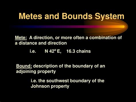
Metes and bounds is a legal description used to define the boundaries of a piece of land. It involves specifying the measurements (metes) and directions (bounds) of the property lines. This method is often used in historic deeds and is still employed in some parts of the United States today.
History and Application
Metes and bounds originated in medieval England and has been used in the United States since the colonial era. Historically, it was the primary method for establishing land boundaries due to the lack of precise surveying techniques. Today, it is more commonly used in rural areas where modern surveying methods may not be practical.
Elements of a Metes and Bounds Description
A typical metes and bounds description consists of the following elements:
- Point of Beginning (POB): The starting point for the description.
- Courses: The measurements (distances) and directions of each boundary line.
- Monuments: Physical landmarks or markers that establish property boundaries, such as trees, fences, or stones.
- Closing Statement: A statement that the description has returned to the Point of Beginning.
Example of a Metes and Bounds Description
“Beginning at a stone monument set at the northwest corner of the property; thence east 500 feet along the north property line; thence south 300 feet along the east property line; thence west 500 feet along the south property line; thence north 300 feet along the west property line to the Point of Beginning.”
Advantages of Metes and Bounds
- Historical Accuracy: Metes and bounds descriptions have been used for centuries and provide a reliable record of property boundaries.
- Flexibility: Metes and bounds allows for the description of irregular-shaped properties and can accommodate changes in land use over time.
- Simplicity: Metes and bounds descriptions are relatively easy to understand and interpret.
Limitations of Metes and Bounds
- Accuracy: Errors in measurement or description can lead to boundary disputes.
- Ambiguity: Incomplete or unclear descriptions can create uncertainty about the precise location of property lines.
- Time-Consuming: Surveying and establishing metes and bounds descriptions can be a time-consuming process.
Modern Applications of Metes and Bounds
In addition to its traditional use in land surveying, metes and bounds has found new applications in recent years, including:
- Legal Documents: Metes and bounds descriptions are still used in deeds, mortgages, and other legal documents to define property boundaries.
- Geographic Information Systems (GIS): Metes and bounds descriptions can be converted into digital data and used in GIS to create accurate maps and land records.
- Property Management: Metes and bounds descriptions help property owners manage and track their land assets, particularly in large-scale real estate developments.
- Boundary Disputes: Metes and bounds descriptions can be used as evidence in court proceedings to resolve boundary disputes.
Conclusion
Metes and bounds remains a valuable tool for defining property boundaries, providing a historical record of land ownership, and facilitating modern applications in land management and GIS. While it has some limitations, its flexibility and accuracy make it a reliable method for establishing and maintaining property rights.


